
9 Drone Applications for Utility Asset Management
For utility asset teams, drone applications are useful when they turn a difficult inspection into evidence that supports maintenance. A photograph of a damaged insulator, a measured vegetation clearance or a mapped washout can help engineers decide what needs attention and where to send a crew.
The value depends on matching the aircraft, sensor and survey method to that decision. Drones can reduce some work at height and improve access to exposed surfaces, but they do not replace electrical testing, internal inspection or engineering judgement. These nine uses show where aerial surveys fit into utility asset management and what each should deliver.
Start with the maintenance decision
Before commissioning a survey, define the question the asset team needs answered. “Inspect this substation” is too broad. “Identify visible defects on these components and record thermal anomalies for engineering review” gives the survey team a usable scope.
Specify the assets covered, the smallest feature that must be visible and the evidence needed to raise a work order. Agree how findings will connect to existing asset identifiers. Otherwise, an inspection can produce hundreds of images without making maintenance planning any easier.
Also assess whether a drone is the right collection method. Enclosed equipment, submerged structures and concealed defects often require other inspection techniques. Site access, weather, electrical hazards and the proposed flight area need assessment before committing to a survey date.
9 drone applications for utility asset management
1. Visual inspection of overhead lines and structures
High-resolution imagery can document damaged insulators, displaced fittings, corrosion, missing components and visible deterioration on poles or towers. It is particularly useful where a ground inspection cannot provide a clear view of elevated equipment.
Plan the capture around individual components rather than taking a few wide photographs of each structure. A useful record includes the structure identifier, component position, overview image and close-up evidence. The image set should let an engineer locate the finding without revisiting the site simply to identify it.
Overhead line inspection is one of the established drone applications where consistent viewpoints make repeat surveys more valuable. Comparable images help reviewers distinguish a new defect from an old condition already scheduled for repair.
The limitation is visibility. An image cannot establish the internal condition of a conductor or prove that an apparently intact component is electrically sound. Treat aerial findings as evidence for the appropriate follow-up inspection or maintenance action.
2. Thermal inspection of substations and electrical connections
Thermal cameras can identify apparent temperature differences across connections and equipment. These differences may indicate a condition worth investigating, particularly when comparable components are operating under similar loads.
Useful deliverables pair thermal images with corresponding visible-light photographs. Record the equipment identifier, operating context and capture conditions so a qualified reviewer can interpret the observation. Where temperature measurement is required, retain radiometric data rather than only a colourised screenshot.
Sunlight, reflections, viewing angle and surface emissivity can affect the image. Equipment loading also changes the meaning of a temperature difference. A bright patch on a thermal display is not, by itself, a diagnosis or a repair priority.
Survey planning must account for the electrical environment and the asset owner's operating procedures. The maintenance team should set the criteria for escalation, including when a thermal observation requires another measurement method. This keeps screening separate from confirmation and avoids turning every visible temperature difference into an unnecessary work order.
3. Vegetation clearance assessment
Vegetation surveys help utilities identify trees and growth that need closer assessment near overhead networks. RGB imagery provides visual context, while suitably specified LiDAR surveys can support three-dimensional measurements of vegetation and conductors.
Vegetation surveying is one of the drone applications where the measurement specification matters more than an attractive 3D model. Define the required accuracy, coverage and clearance reporting method before collection. Conductor position varies with operating and environmental conditions, so a measured gap is not automatically the clearance under every condition.
The deliverable should identify the affected span or structure, show the supporting evidence and distinguish measured clearance from any modelled allowance. Asset engineers should supply the clearance criteria rather than leaving the survey provider to invent thresholds.
Season also matters. A leaf-off survey and a leaf-on survey answer different questions. Record the survey date and vegetation condition, then use repeat data to inform cutting schedules. Growth forecasts should remain separate from observed measurements so planners can see which findings are certain and which depend on assumptions.
4. Solar farm condition screening
Aerial thermal surveys can screen large solar arrays for patterns that warrant investigation. Visible-light imagery adds context for damaged modules, shading, surface contamination and other observable conditions.
The output needs to identify the affected module or string clearly enough for a technician to find it. Agree the array naming convention before flying and ensure the map matches the operator's records. A thermal image without a reliable location can create another search task for the maintenance crew.
For solar drone applications, repeatable capture conditions make comparisons more useful than simply collecting more images. Record irradiance, weather and operating state because changing conditions can change the thermal pattern. Avoid comparing surveys as though they were equivalent when the capture conditions differ.
Aerial screening does not establish the cause of every anomaly. Electrical testing or closer inspection may still be needed. Group findings by evidence quality and recommended follow-up rather than labelling every unusual pattern as a failed module. That distinction helps operators prioritise investigation without overstating what the survey proves.
5. Wind turbine blade and tower inspection
Drones can collect close visual records of accessible blade and tower surfaces. Depending on image quality and viewing angle, these records can document leading-edge erosion, coating damage, visible cracking or damage around external fittings.
Inspection must be coordinated with the turbine operator, including the required stopped state and site isolation arrangements. Capture planning should account for blade position, lighting and the views needed to cover each inspection area.
Location is as important as image resolution. A finding should identify the turbine, blade, surface and position along the blade, with an overview that makes the close-up understandable. Consistent naming helps maintenance teams compare repeat inspections and plan access for repairs.
A visible surface mark does not reveal the full depth or internal extent of damage. Engineering assessment or another inspection method may be necessary before deciding on repair scope. For rotating machinery, drone applications support condition assessment; they do not replace the operator's decisions about whether equipment is fit to return to service.
6. Pipeline corridor and crossing monitoring
Aerial surveys can document changes along pipeline corridors, including erosion, slope movement, exposed sections, damaged access routes and nearby excavation activity. Repeated coverage is useful at river crossings and other locations where surrounding ground conditions affect the asset.
Compare current observations with a dated baseline. Report the location and extent of a change, supported by photographs or measured survey data. Where a finding needs a site visit, include enough access information for the responding team to plan its work.
This application concerns observable corridor conditions. Ordinary RGB or thermal imagery cannot establish the condition of a buried pipe wall. Nor should a temperature difference be presented as proof of a leak without supporting evidence.
Gas detection is a separate, sensor-specific task requiring a suitable instrument and a validated method. Do not assume an aircraft equipped for photography can perform it.
Pipeline teams should therefore define distinct scopes for corridor surveillance, engineering survey and leak investigation. Keeping these tasks separate makes the findings easier to interpret and prevents a general aerial survey being treated as a complete pipeline integrity assessment.
7. Inspection of reservoirs, dams and water infrastructure
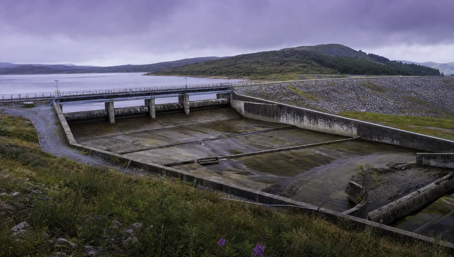
Water-sector drone applications can document exposed surfaces that are awkward to inspect closely, including reservoir embankments, spillways, treatment structures and external pipework. Imagery can help locate visible cracking, spalling, displaced protection materials or changes around drainage features.
The survey brief should distinguish a visual condition record from a measured survey. A photographic inspection may be sufficient to locate a defect, while measuring displacement or comparing surface geometry requires a suitable survey method and accuracy checks.
Photogrammetry can struggle with moving water, reflections and surfaces that lack visible texture. Do not assume that every part of a reconstructed model has the same reliability. Identify gaps and areas of poor reconstruction in the deliverable.
Aerial images also cannot establish the condition of submerged components or the internal stability of an embankment. Use them alongside the asset owner's inspection and monitoring programme. For repeat visits, preserve the original viewpoints and location references so engineers can compare the same areas rather than relying on memory or loosely matched photographs.
8. Construction progress and as-built asset mapping
During utility construction, repeat aerial surveys can record visible progress, site layout and the position of installed assets. Orthomosaics and point clouds can support coordination between surveyors, contractors and the asset owner.
Construction-focused drone applications are most useful when survey dates match project decisions. Capturing an open trench before backfilling, for example, may preserve information that will no longer be visible at handover. That requires coordination with the construction team rather than an arbitrary monthly flight schedule.
Agree the coordinate system, control requirements and acceptance checks before collection. An RTK-equipped aircraft alone does not demonstrate that the final deliverable meets the project's accuracy requirement. Use appropriate independent checks and report the achieved results.
For handover, connect mapped objects to the asset register and distinguish verified as-built information from temporary works or unconfirmed observations. A polished map should not be treated as authoritative simply because it looks precise. The receiving team needs to know what was captured, when it was captured and which checks support its use.
9. Storm damage assessment and repair prioritisation
After severe weather, drones can help teams assess damaged structures, fallen trees, flooding and blocked access routes. A wide-area overview can help planners decide where a closer inspection or repair crew is needed.
Organise collection around the response team's questions: which assets appear affected, whether access is obstructed and what further assessment is required. Deliver findings in small, usable batches rather than waiting for a complete survey product while crews need information.
Operating conditions remain part of the decision. Wind, precipitation, damaged infrastructure and other aircraft can restrict what is practical. Coordinate activity through the incident management arrangements rather than allowing separate teams to survey the same area independently.
Emergency drone applications need particularly clear confidence labels. “Visible damage”, “suspected damage” and “not inspected” describe different situations. A missing observation must not be interpreted as confirmation that an asset is sound. Record coverage gaps and route uncertain findings to the appropriate engineer so repair priorities reflect the evidence actually available.
Make the findings usable by the asset team
Define the inspection record before collection
The inspection deliverable should fit the system used to assign and close maintenance work. Agree the required fields with that team, not only with the person commissioning the flight.
| Record field | Purpose |
|---|---|
| Asset identifier and location | Connects evidence to the correct equipment |
| Component and observation | Describes what was actually seen |
| Capture date and conditions | Provides context for interpretation |
| Supporting images or measurements | Lets reviewers check the finding |
| Confidence and inspection limitations | Separates observation from uncertainty |
| Assigned action and owner | Makes responsibility for follow-up clear |
Useful drone applications end with an accepted finding or a documented decision, not merely an uploaded folder. Keep raw observations separate from engineering conclusions, then retain the connection between them when a work order is raised.
Set data handling and access requirements
Utility imagery may reveal equipment layouts, access arrangements and detailed asset locations. Agree who can access the data, where it will be stored and whether subcontractors may retain copies. Set retention and deletion requirements before collection begins.
Limit unnecessary capture of neighbouring properties and people. Where those details are not needed, exclude them from routine deliverables or apply suitable redaction. Avoid distributing unrestricted links to sensitive surveys simply because the files are too large for email.
Specify export formats as well. The utility should be able to retrieve images, measurements and asset references in usable forms rather than depending on one viewer indefinitely. Confirm how corrected findings and revised classifications will be tracked so obsolete reports do not continue circulating after an engineering review.
Compare the complete cost, not just flying time
The business case for drone applications should include mobilisation, site coordination, sensor costs, processing and engineering review. Add repeat visits, storage and any conventional inspection still needed to confirm findings.
Compare equivalent outputs. A rapid aerial screening survey and a detailed hands-on inspection do not answer the same questions, so their headline prices are not directly interchangeable.
A pilot project can track cost per accepted asset record, the proportion of findings that lead to action and the number of repeat visits caused by incomplete evidence. Assess changes in exposure to work at height or difficult terrain without assuming that using a drone removes all inspection risk.
If environmental performance forms part of the case, include vehicle travel, mobilisation and repeat surveys. An electric aircraft alone is not enough evidence for a lower-impact inspection method.
Frequently asked questions
Which utility assets are best suited to aerial inspection? Exposed assets with observable surface conditions are good candidates, including overhead structures, solar arrays, turbine blades and reservoir infrastructure. Buried, enclosed or submerged components usually need other inspection methods as well.
Do all utility surveys need thermal cameras or LiDAR? No. High-resolution RGB imagery may answer a visual inspection question. Thermal imaging supports temperature-pattern assessment, while LiDAR can support specified three-dimensional measurements. Select the sensor after defining the required evidence.
Can automated analysis decide which assets need repair? Automated tools can help flag images for review, but their findings need validation against the asset type and survey conditions. Maintenance priorities should follow the utility's engineering criteria, with uncertainty recorded rather than hidden.
How often should inspections be repeated? Set intervals according to asset condition, failure consequences and the existing maintenance programme. Event-driven surveys after storms or construction activity can supplement scheduled inspections. Repeat drone applications need comparable coverage and capture conditions if the aim is to assess change.
Assess the workflow before expanding
Choose one asset group and agree the evidence standard with the engineers who will use it. Test the complete process, including review and maintenance handover, before increasing coverage.
For utility-sector context, see Dronedesk's National Grid case study. When assessing operations software, review Dronedesk's published features against your team's requirements.
 Choosing Drones for Agricultural Use Beyond Crop Spraying →
 9 Drone Applications for Utility Asset Management →
 How to Write a Drone Business Plan That Tests Your Margins →
 How to Choose a Search and Rescue Drone for Rural Operations →
 How to Carry Out a Drone Site Survey Before Mobilising →
 How to Evaluate Drone Companies for Long-Term Contracts →
 What a First Responder Drone Programme Needs Before Deployment →
 Law Enforcement Drones and Their Role in Evidence Collection →
 What Are UAV Systems? Aircraft, Payloads and Ground Equipment →
 7 Best Flight Planning Apps for Commercial Drone Teams →